Climate Risk
By Dr Stuart Auld, Director of Science, refinq
-
One River, many realities: Why trust in data shapes adaptation decisions in the Senegal River Basin.
The Senegal River Basin shows how climate adaptation, water governance and local livelihoods are closely connected. At COP30 in Belém, refinq explored how digital twins, geospatial climate and nature risk data, together with indigenous knowledge, can create a single source of truth for OMVS and its partners and turn shared data into trusted cross-border resilience decisions.

Why trust in data shapes adaptation decisions in the Senegal River Basin.
As part of my role as Director of Science, I represented refinq at COP 30 in Belém, Brazil. This was a fantastic opportunity to learn about projects that have delivered real change on the ground and to better understand how refinq can play an even bigger role in unlocking climate and nature action. The Senegal River Basin Development Project is one of these projects.
The Senegal River: A little geography
Few rivers show the complexity of climate cooperation like the Senegal. The Senegal River begins high in the Fouta Djallon plateau of Guinea, where dense forests and cloud-fed springs gather into narrow headwaters. It flows north through Mali’s semi-arid plains, bends west to form the border between Mauritania and Senegal, and finally reaches the Atlantic at Saint-Louis. Stretching nearly 1,800 kilometres, the river links four nations, dozens of languages, and a complex web of livelihoods that depend on its seasonal rhythm.
For centuries, that rhythm has defined life across the basin. In the upper reaches, smallholder farmers rely on early rains for millet and groundnut crops. In the Sahelian middle valley, communities depend on flood recession farming and livestock movement that follow the river’s rise and fall. Downstream, the delta’s wetlands support rice cultivation, fishing, and mangrove ecosystems that buffer coastal towns from storms. Each stretch faces a different challenge. Upstream, deforestation and soil loss. Mid-valley, drought and salinisation. Downstream, flooding tied to sea-level rise.
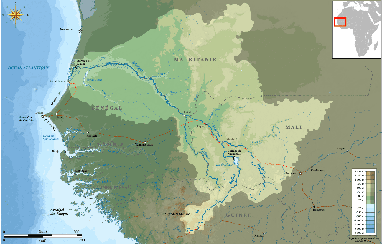
Figure 1. The Senegal River Basin from source to sea
Over the past decade these pressures have intensified. Satellite data and national assessments show the rainy season shortening and becoming more erratic, with heavier bursts of rain after longer dry spells. Floods in 2020 and 2022 displaced thousands along the lower valley, while droughts in 2014 and 2017 reduced crop yields by more than a third in some communes. Mangrove cover has declined where salinity intrudes, and upstream dam regulation has altered sediment flows. Yet the basin also remains a lifeline for hydropower, irrigation, and navigation, functions that now sit in delicate balance with ecosystem health.
This diversity of needs makes the Senegal River Basin both a shared opportunity and a shared responsibility. Every decision, whether to store water, release it, divert it, or protect it, ripples across borders and communities. That is why the Organisation pour la mise en valeur du fleuve Sénégal (OMVS) has become a model for cooperative water governance, and why it drew global attention at COP30 in Belém, where the basin’s future was discussed as a test case for science-based adaptation and trust across nations.
COP30 in Belém: Data, insights, and most importantly, local knowledge
On 10 November, I attended the high-level panel “Using Science to Inform Policy Decision-Making: The Development of the Senegal River Basin”. This was held as part of the UNFCCC Global Innovation Hub Dialogues in the Blue Zone, where the future of the basin was discussed as both a technical and social challenge.
Professor Phoebe Koundouri (Athens University of Economics and Business; SDSN Global Climate Hub; AE4RIA) outlined how digital twin technologies can support science-based, data-driven, and collaborative decision-making for the sustainable management of one of West Africa’s most important transboundary ecosystems. Her contribution built on progress made at the OMVS Systemic Innovation Workshop in Dakar, where partners from OMVS, AE4RIA, SDSN, and the UNFCCC Global Innovation Hub advanced the shared goal of building a transparent and integrated digital twin for water management.
The panel was moderated by Niokhor Ndour, Secretary General of OMVS, and included Ketan Patel (Chair, Force for Good), Warīn Flores (Founder and Principal Investigator, KINRAY HUB), and Massamba Thioye (Principal Advisor, UNFCCC). Each speaker approached the question of resilience from a different angle: investment, innovation, and institutional cooperation.
Warīn Flores focused on how indigenous and local knowledge must be treated as primary data, not as cultural commentary. Essentially, this knowledge is the fundamental, not the ‘nice-to-have’. His argument resonated across the session and had a particular impact on me. In particular, he described communities in river landscapes as both the observers and the first responders to environmental change, and stressed that any credible data architecture must include their observations and definitions of vulnerability. As custodians of the landscape, these peoples’ differing experiences of how their livelihoods and culture are affected by nature and physical climate risks are key. Different peoples will have differering nature and climate vulnerabilities for the same activities, and this needs to be embedded into the architecture of how data are reported, analysed and communicated. Indeed, it was abundantly clear how this perspective complemented Professor Koundouri’s digital-twin concept, highlighting that modelling and lived knowledge are two halves of the same coin.
Together, the speakers painted a picture of what climate cooperation could look like when science, finance, governance, and community insight share one platform. The conversation in Belém made clear that resilience depends as much on who contributes the data as on the quality of the model itself.
Building a common source of truth
The discussions in Belém echoed a question we face daily at refinq: how do we represent vulnerability in a way that is both scalable across large areas, but captures the real-world nuances across communities?
In our work, we’ve learned that every asset carries multiple forms of vulnerability. A single infrastructure site can show one profile of exposure when viewed through climate data, and quite another when the people who operate or depend on it describe their own experience. A power substation, for example, might appear moderately exposed to flood risk on paper. But when engineers input design specifications, soil compaction data, or historic maintenance records, a second layer of vulnerability often emerges. The same is true for communities. Two villages on the same floodplain can face entirely different levels of risk depending on their livelihoods, housing materials, or access to seasonal grazing land.
This microvariation in vulnerability is not noise in the data; it is the data. Understanding this microvariation is central to effective nature and climate risk management. The challenge is to build systems that can record it without losing coherence across scales or jurisdictions. That is what a Single Source of Truth (SSOT) should achieve: a common framework that can flex to include local detail while maintaining scientific traceability and transparency. Flexible, but with a clearly described audit chain.
The refinq management platform has been designed with that principle in mind, and the Senegal River Basin provides a fantastic project to test our ideas and functionality. Our platform provides a structured space where users can combine geospatial analyses of climate and nature risks with their own measures of vulnerability and dependency. Together, they create a living picture of how climate hazards and ecological change interact with real people and real assets, and this means our GaiaGuide function can make recommendations for nature and climate action that are tailored to the needs of the business and/or societal needs of those who exist on that landscape.
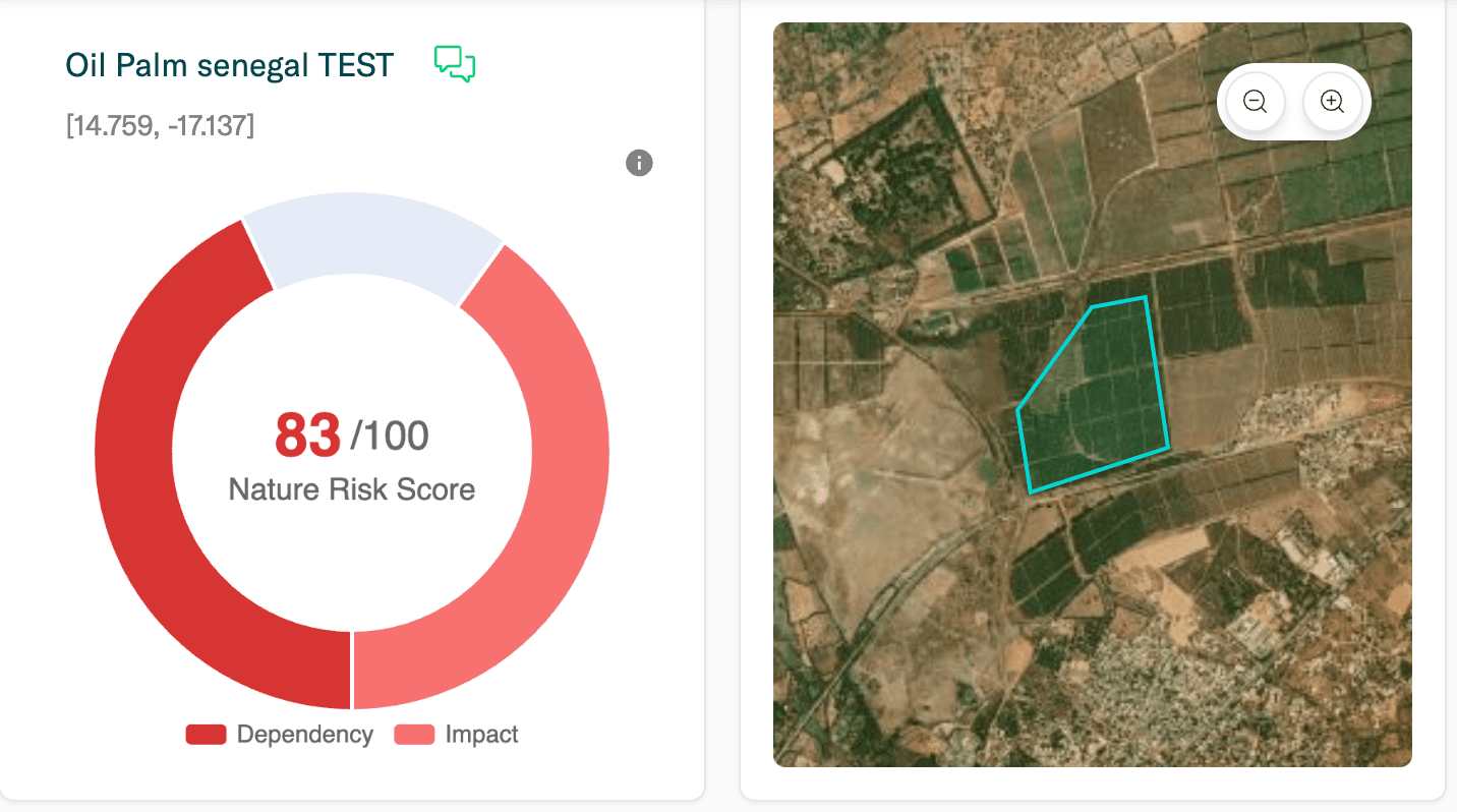
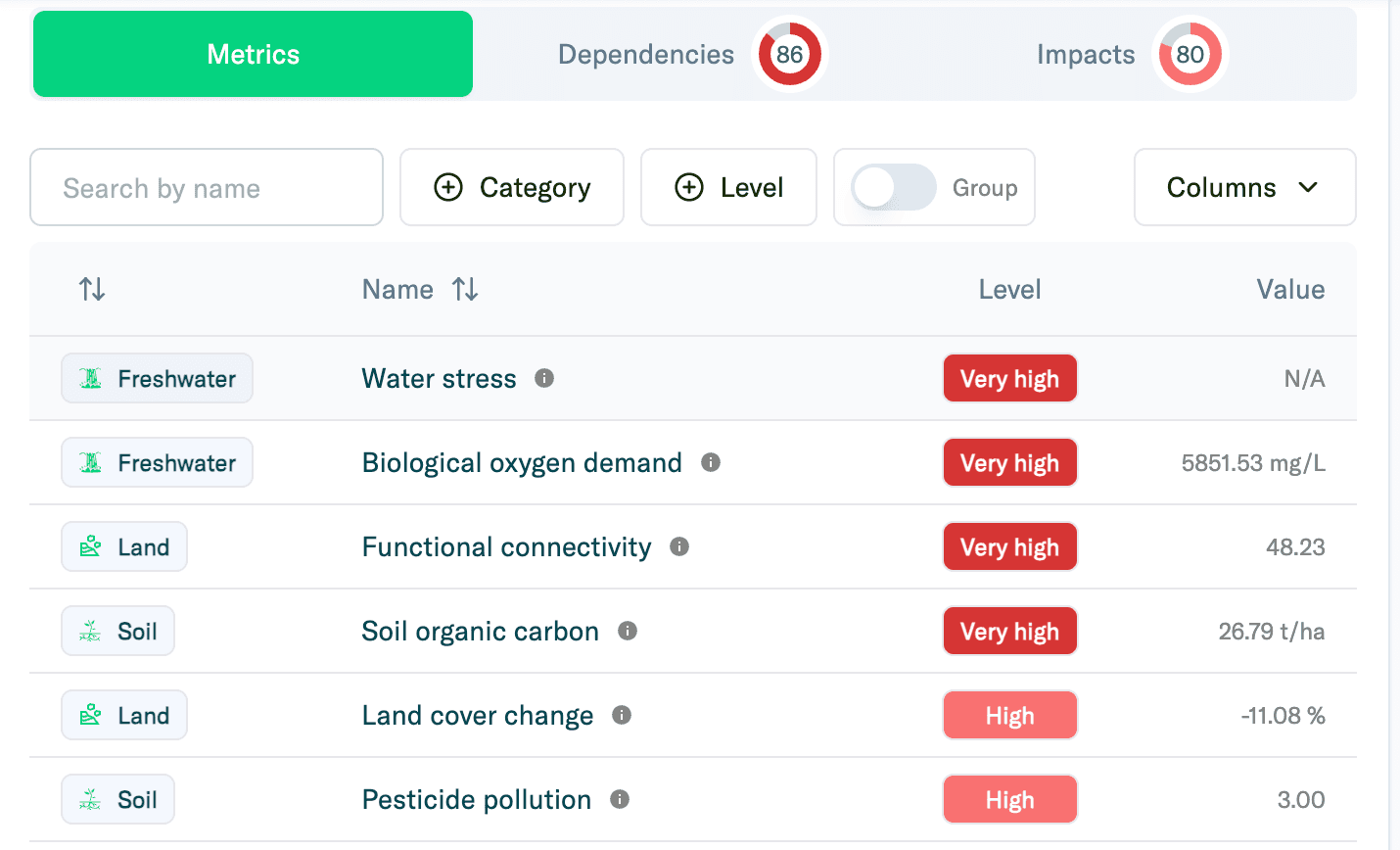
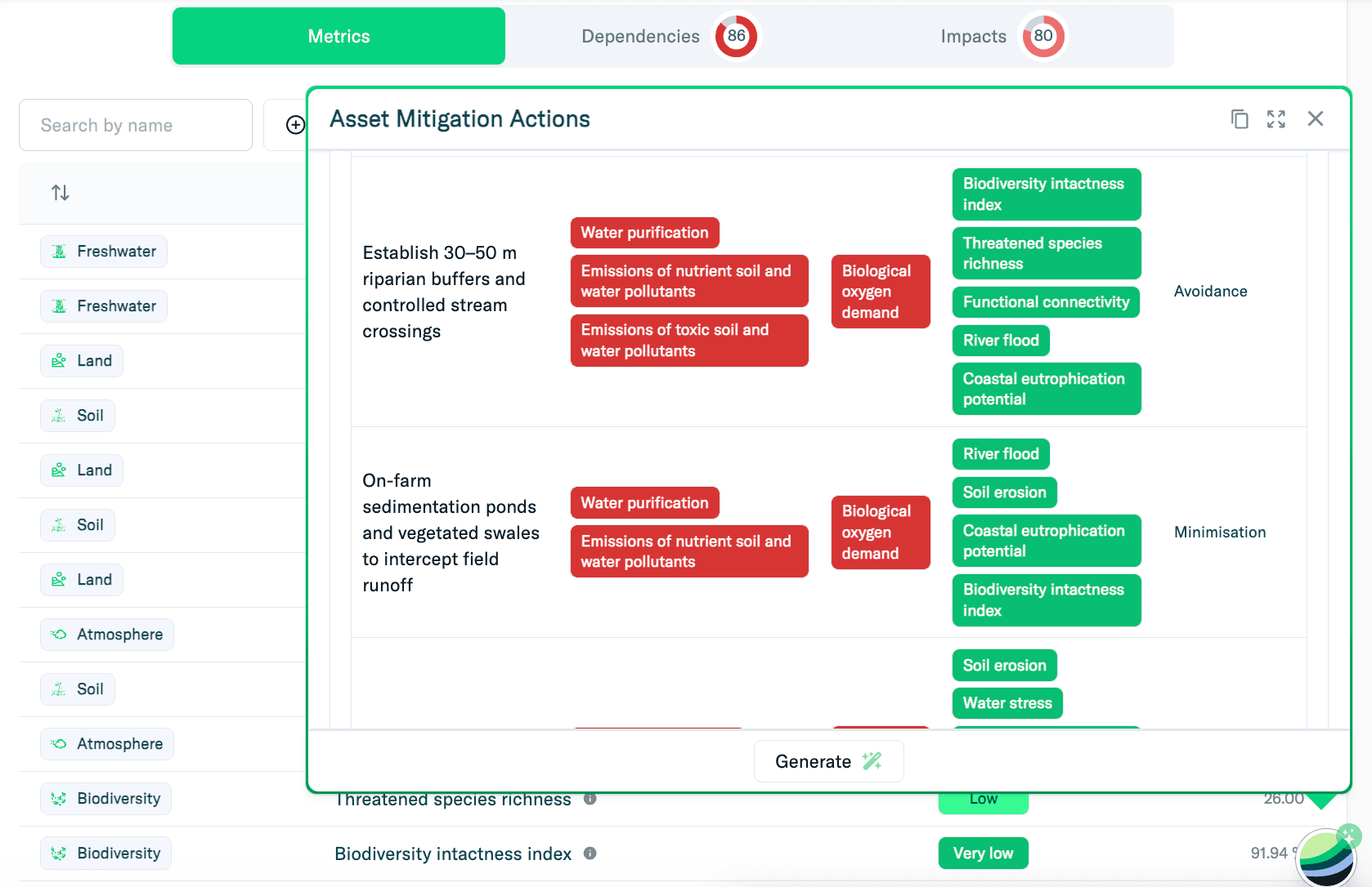
Figure 2. Screenshots from the refinq platform showing overall Nature Risk Score, specific high nature risks and a section of the suggested adaptation actions from GaiaGuide.
The accompanying screenshots from the refinq platform illustrate this approach. They show climate and nature risk layers across sites in the Senegal River Basin: from inland flood-prone plains to coastal deltas. Each location reflects a different combination of physical hazard, ecosystem dependency, and social exposure. These variations are not anomalies; they are the signatures of local reality.
In complex, multi-jurisdictional projects like the Senegal River Basin initiative, maintaining a shared, trusted evidence base is as important as the data itself. The ability to integrate local input, test assumptions, and show transparently how risks differ within the same landscape is what turns information into governance. That is how shared knowledge becomes shared resilience.
Shared knowledge for shared resilience across the Senegal River Basin
The Senegal River Basin shows what long-term cooperation can achieve. For nearly half a century, OMVS has proven that shared water can build shared peace. The work now under way with the UNFCCC Global Innovation Hub, AE4RIA, and SDSN extends that idea into the digital age, creating tools that link science, finance, and local knowledge in one coherent system.
At refinq, we see this as a glimpse of what effective climate and nature management could look like across many regions. A platform that holds a single, trusted source of truth. A framework that respects both global standards and local realities. And a process where data is not only measured, but contributed, questioned, and improved by the people closest to risk.
The Senegal River Basin reminds us that trust is the rarest and most valuable currency in climate adaptation. It cannot be coded or bought; it has to be earned through openness and collaboration. If the digital twin of the basin succeeds, it will not be because of its technology alone, but because it gives everyone, from government engineers to local custodians, a place in the same conversation.
That is the spirit we aim to support. Shared knowledge, carefully managed and openly exchanged, is the foundation of resilience. The river itself has always known this truth: strength comes from confluence.